Bomb Cyclone
A “bomb cyclone,” a rapidly intensifying storm, is set to hit the West Coast. This particular storm is expected to be especially powerful and could bring over a month's worth of rain, hurricane-force winds, and several feet of snow to parts of the Pacific Northwest and Northern California.
Chasing the Current - Episode 2
11/19/20243 min read
A Once-in-a-Decade Bomb Cyclone Takes Aim at the West Coast
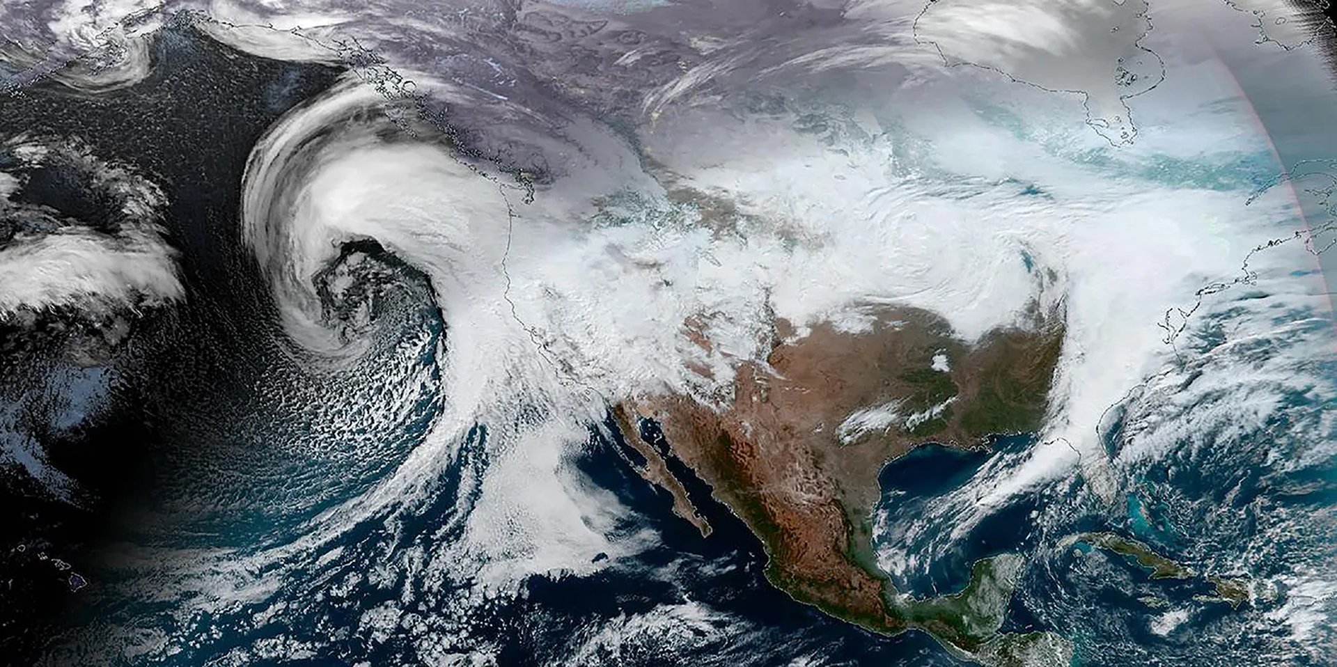
The West Coast is bracing for an extraordinary storm system—a "bomb cyclone" paired with an atmospheric river—that is set to unleash unprecedented rainfall, hurricane-force winds, and significant snowfall beginning Tuesday. This rare weather event promises to disrupt daily life and could rank among the most intense storms recorded in the region.
A Rare but Dangerous Phenomenon
Bomb cyclones, while not unheard of, typically appear about once a year in the U.S. What sets this storm apart is its exceptional intensity and timing, making it a significant threat to the Pacific Northwest and Northern California. As this massive system moves in, it serves as a stark reminder of nature’s power and the importance of preparation. Stay safe, stay informed, and be ready for what could be one of the most powerful storms of the decade.
What Is a Bomb Cyclone?
A bomb cyclone is a rapidly intensifying storm that experiences a sharp drop in barometric pressure—at least 24 millibars within 24 hours—a phenomenon known as bombogenesis. This process creates a powerful system marked by strong winds and heavy precipitation.
While bomb cyclones share some characteristics with hurricanes, they are not tropical in nature. Unlike hurricanes, which thrive on warm ocean waters, bomb cyclones arise when cold Arctic air clashes with warm air, often in mid-latitudes. These storms tend to occur between late fall and early spring when temperature contrasts are most pronounced.
What’s Happening Off the West Coast?
The bomb cyclone forming off the Pacific Northwest is remarkable not only for its intensity but also for the speed of its development. Meteorologists predict it could triple the criteria needed to qualify as a bomb cyclone, earning it the rare label of a “triple-bomb.”
This system is set to combine with an atmospheric river—a vast plume of water vapor that moves through the atmosphere like a river—creating a deadly one-two punch of torrential rain and heavy mountain snow.
What to Expect from a bomb cyclone
Here’s a breakdown of the expected impacts:
Rainfall
Northwestern California could see 16+ inches of rain in just 48 hours—more than a month’s worth of precipitation.
The northern San Francisco Bay area, particularly north of the Golden Gate Bridge, is at high risk for urban flooding, debris flows, and river flooding.
Rainfall could peak Wednesday and Thursday, with up to 8 inches in a single day in some areas.
Snowfall
Higher elevations in the Cascades and Sierra Nevada are under blizzard warnings, with 1 to 4 feet of snow expected by Wednesday.
Strong winds could create whiteout conditions, making travel on major highways like I-5 and Highways 36 and 140 nearly impossible.
Winds
Inland areas may experience winds of 35 to 50 mph, with gusts up to 70 mph.
Coastal regions and higher elevations could see hurricane-force gusts reaching 85 mph, leading to widespread power outages and structural damage.
Why Is This Storm a Big Deal?
The National Weather Service has issued a Level 4 of 4 high risk for flooding rainfall on Thursday—a rare designation that occurs on fewer than 4% of days annually but accounts for over 80% of flood-related damage and 40% of flood-related deaths.
Meanwhile, winds strong enough to warrant hurricane-force warnings have been issued for parts of the coastal waters. The combination of these elements makes this storm a once-in-a-decade event that demands attention and preparation.
How to Stay Safe
With hazards ranging from flooding to power outages, preparation is key:
Stock up on essentials: Ensure you have food, water, batteries, flashlights, and a first aid kit.
Prepare for travel disruptions: Avoid driving during peak storm conditions, especially in flood-prone or mountainous areas.
Secure your property: Clear gutters, tie down loose items, and have sandbags ready if you’re in a flood zone.
Stay informed: Keep an eye on local weather alerts for updates and evacuation notices.


Click to listen to this podcast episode.
Be proactive, be prepared, be safe... Start Now!